Brush Creek mountain bike trails
Discover one of the best areas for mountain biking in Crested Butte, Brush Creek:
The Brush Creek zone is one of the premier mountain biking areas near Crested Butte, offering a dense network of trails just minutes from town. From iconic expert rides like Teocalli Ridge to intermediate loops and beginner-friendly connectors, Brush Creek delivers epic scenery, challenging terrain, and classic Crested Butte riding.
- Home to legendary trails like Teocalli Ridge, Strawberry, Strand Hill, and the 409s.
- Trail options for all levels, from easy connectors to high-alpine expert descents.
- Peak riding in summer and fall with wildflowers in July and golden aspens in September.
______________________________________________________________________________________
The Brush Creek trails are a can’t-miss zone for mountain biking around Crested Butte. The Gunnison Valley has several trail systems and zones with high concentrations of trails. One of these zones is the Brush Creek drainage, which is just a few miles southeast of the town of Crested Butte. It includes the famous and beloved Teocalli Ridge trail. This guide to the trails around Brush Creek includes route descriptions, riding tips and other things to do in the area.
Where is Brush Creek Road?
Brush Creek Road begins on the east side of Highway 135, 2.4 miles south of Crested Butte. Brush Creek Road, also known as Gunnison County Road 738, extends from its intersection with Highway 135 east over Pearl Pass towards Aspen. This area is bursting with mountain bike trails, and there are several hiking trails, too. Gunnison National Forest comprises most of the public land in this zone. Maroon Bells-Snowmass Wilderness is also accessible from the Brush Creek drainage.
Crested Butte on Trailforks.com
Best MTB trails in Brush Creek
Click on the trail name to jump to its description:
Upper Upper Loop and Whetstone Vista
A switchback on Teocalli Ridge trail
Teocalli Ridge
Teocalli Ridge trail stats
- Round-trip distance: 11.5 miles
- Skill level: Advanced/expert
Teocalli Ridge overview
Teocalli Ridge is one of Colorado’s most beloved and famous mountain bike trails. It’s also one of the shorter epic rides in Crested Butte. A steep climb is rewarded with a sustained four-mile downhill section.
Where is the trailhead for Teocalli Ridge?
The Teocalli Ridge trail loop starts at the Brush Creek Tent City group campsite, which is about six miles east of Highway 135 on Brush Creek Road. You can either park at the Tent City campsite or farther west on Brush Creek Road, where there are several other parking areas.
Teocalli Ridge trail description
From the Brush Creek Tent City group campsite, ride four miles north on West Brush Creek Road. This mellow fire road is an easy pedal (especially considering what comes next). About halfway up the road is a major creek crossing. This creek crossing is not deep, but it is long. Wade through knee-deep, ice-cold water for nearly a quarter mile before getting to the other side. At the base of the ridge, the singletrack begins on the right. Grind three miles to the top of the ridge. This section is brutally steep and will almost certainly require anyone not on an e-bike to hike their bike. Find the open, rocky area at the top of the ridge to plop down, eat a snack and enjoy the view of the Pearl Mountain and Castle Peak. The descent begins here. Cruise over rocks and roots on the steep upper section. Then, hone your cornering skills through about a dozen switchbacks in a grove of aspen trees. You’ll be moving fast when you emerge from the trees into a meadow that is filled with wildflowers in June and July. Turn right onto Brush Creek Road and continue back to where you started. There is another creek crossing in this section. Take care in spring when the water is deepest.
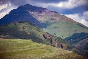
The distinctive peak of Teocalli Mountain
Strawberry
Strawberry trail stats
- Distance: 2.6 miles, more if you ride it as a loop with other trails
- Skill level: Intermediate/advanced
Strawberry trail overview
Strawberry trail (formerly Trail 402) is tucked behind the Strand Hill trail system. It’s one of several Crested Butte trails that remain largely undiscovered, and it’s well worth a ride. The downhill section of Strawberry rides a lot like 409.5, with big root and rock drops. However, Strawberry is easier to get to than 409.5.
Where is the trailhead for Strawberry trail?
Park at the limited parking along Brush Creek Road near the base of Strand Hill, or ride from the Brush Creek trailhead.
Strawberry trail description
To access Strawberry trail, start at the intersection of Farris Creek Road and Brush Creek Road. This is about five miles east of Brush Creek Road’s intersection with Highway 135. There is a green gate here; leave it as you found it. Ride up Farris Creek Road, bearing right at the fork about a mile in. At the next fork, keep left to stay on Farris Creek Road. In about two more miles, find the brown Strawberry trail sign on the right side of the trail. This is where the singletrack begins. Keep climbing through aspen groves for about another mile before you reach the barbed-wire fence at the top. Again, leave the gate as you found it. The trail curves through the aspens, sending you launching over technical obstacles like roots and boulders. At the end of the trail is a large meadow. Soak in the views before carefully crossing the stream. Use caution at this creek crossing during spring runoff. Turn left on Brush Creek Road. You can either take Brush Creek Road all the way back to where you started or hop onto 409 and Canal trails to add more singletrack.
Strand Hill trail
Strand Hill trail system
Strand Hill trail stats
- Distance: Varies
- Skill level: Intermediate
Strand Hill overview
The Strand Hill trail system includes Strand Hill trail, Strand Bonus and Canal. Strand Hill Road is also commonly used as an uphill route. These short trails can be linked and ridden as loops. The Strand Hill trails make a convenient lunch ride or after-work lap. These trails are usually some of the first Crested Butte MTB trails to dry out in spring.
Where is the trailhead for Strand Hill?
There is limited parking at the bottom of Strand Hill Road where it intersects Brush Creek Road. There are also a few parking spots at the base of Canal Trail. There are larger parking lots at the Brush Creek trailhead and at the intersection of Brush Creek Road and Highway 135.
Popular Strand Hill route
The most common Strand Hill route starts at the bottom of Canal Trail where it intersects Brush Creek Road. There is a shallow canal crossing here; use caution during high water. Climb up Canal for about a mile; then turn right onto Strand Bonus. Continue climbing for 1.4 miles; then turn left onto Strand Hill Road. Climb to the top of this steep, rocky road and catch your breath in the small meadow at the top. Check out a great angle of Teocalli Mountain from there. Enjoy the descent on Strand Hill trail before getting back onto Canal trail to take you back to the beginning.
Strand Hill trails descriptions
- Strand Hill trail: The jewel of the Strand Hill trail system. This trail starts at the top of Strand Hill Road and descends steeply north towards Brush Creek. It should only be ridden south to north (downhill). Sharp corners and surprisingly large roots will keep you on your toes!
- Canal: Canal can be ridden both directions. This cross-country cruiser trail takes you back to Brush Creek Road after riding Strand Hill trail. Link it with Strand Bonus as an uphill route to skip part of Strand Hill Road.
- Strand Bonus: This 1.4-mile trail is an intermediate jaunt through aspen forest. As mentioned earlier, it links Canal with Strand Hill Road, providing extra singletrack mileage.
- Strand Hill Road: This is a brutally efficient uphill route to access Strand Hill trail. This steep, sunny road is not often called “fun,” but it’s the quickest way to the top of the hill. The downhill is well worth the climb.
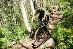
Brice Shirbach flies down Trail 409.5
Trail 409, 409.5 and Point Lookout
409s trail stats
- Round-trip distance: 13 miles
- Skill level: Advanced/expert
409s overview
The 13-mile length of this epic high-country ride is deceptive, as most riders take several hours to complete it. Grind 8.5 miles up Farris Creek Road, Trail 409 and Point Lookout to earn a ripping downhill reward on 409.5.
Where is the trailhead for the 409s?
Park in the limited parking at the bottom of the Strand Hill Road or at one of the parking lots farther west on Brush Creek Road.
409s trail description
Ride from the bottom of Strand Hill Road, bearing right at the first fork. At the next fork, climb over the stile to start riding Trail 409, also known as Farris Creek trail. After about three and a half miles of tough climbing through scree fields, aspen groves and one of the best meadows in the Gunnison Valley, turn left onto Point Lookout trail. Crank up this trail for two more miles of breathless but beautiful singletrack. Turn left on 409.5 and enjoy a ripping three-mile descent. Expect medium to large step-downs, especially at the top. Ride back down the road to where you started.
Upper Upper Loop/Whetstone Vista
Upper Upper Loop trail stats
- Round-trip distance: Varies
- Skill level: Intermediate
Upper Upper Loop overview
The Upper Upper Loop and Whetstone Vista connect the towns of Crested Butte and Mt. Crested Butte to Brush Creek Road. These Brush Creek mountain bike trails are convenient connector trails for creating loop routes.
Upper Upper Loop trail description
The north end of the Upper Upper Loop begins at the south end of the Upper Loop trail, just past the top of Tony’s trail. Upper Upper Loop extends 2.6 miles south to Brush Creek Road. Upper Upper Loop is quite rocky. It can be ridden either direction. Though this trail is a fun cross-country ride on its own, its real strength lies in connecting major north valley hubs. About halfway along the Upper Upper Loop is an option to turn onto Whetstone Vista trail, which also terminates at Brush Creek Road. Whetstone Vista is a scenic intermediate trail that provides a pretty view of Whetstone Mountain to the west.
The Deli trail in fall
Deli
Deli trail stats
- Distance: 1.8 miles
- Skill level: Beginner
Deli trail description
Much like the Upper Loop, the Deli trail provides easy access from Crested Butte to Skyland and Brush Creek. Take this trail to avoid biking or walking on Highway 135. The Deli trail starts near the Crested Butte Community School and parallels the highway. Eventually it crosses the Slate River and ends at Brush Creek Road. The trail is wide and flat.
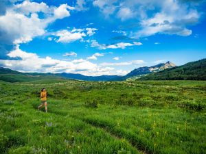
Deer Creek trail is also a great spot for trail running due to its relatively mellow grade and gorgeous scenery.
Deer Creek
Deer Creek trail stats
- Distance: 10.7 miles
- Skill level: Intermediate/advanced
Deer Creek overview
Deer Creek is one of the only long trails in Crested Butte that is classified as cross-country. With several climbs and descents at high elevation over nearly 11 miles, it’s an endurance ride through pristine country. The trail is accessible both from Brush Creek Road and from Gothic, north of Crested Butte.
Where is the trailhead for Deer Creek?
Deer Creek is typically ridden starting in Brush Creek and ending in Gothic (south to north). Park on one of the parking lots on Brush Creek Road or in the Tent City lot by the fork in Brush Creek Road. There is a pit toilet here.
Deer Creek trail description
Deer Creek is a grueling ride, but not without payoffs. This is one of the best rides in the valley for wildflowers and stunning valley views. It’s also often one of the first backcountry trails to open in spring. The Deer Creek doubletrack begins on the west fork of Brush Creek Road, about a mile in on the left side as you’re riding north. After about a mile, the doubletrack turns to singletrack. Here is the first and longest downhill section, which is neither long nor technical. There are three major climbs throughout the trail, with the biggest one being second. The trail traverses the side of a ridge overlooking the East River Valley. The East River meanders below, sparkling in the sun. Gothic Mountain towers to the north. The trail cuts through several large meadows which are covered in larkspur, lupine and mule’s ears in June. After 10.7 miles, the trail concludes in the tiny town of Gothic near Schofield Pass. Intrepid riders ride down Gothic Road to Brush Creek Road to create an epic 29-mile loop.
Do I need four-wheel-drive for Brush Creek Road?
The section of Brush Creek Road referenced in this article is all accessible with a passenger vehicle. Beyond the fork with West Brush Creek Road (Forest Road #738.2A), four-wheel-drive is mandatory. Pearl Pass is a difficult 4×4 route.
Best times to mountain bike in Crested Butte
Summer and fall are the best times to mountain bike in Crested Butte. Snowfall varies each year, but usually the lower-elevation Brush Creek mountain bike trails, such as Strand Hill, start to dry out by mid-June. The higher-altitude trails like Teocalli Ridge are usually rideable by July. The Brush Creek trails remain open through fall. The first snow can occur anytime between early October and Thanksgiving. This Colorado mountain bike trip gear guide will advise you on what equipment to bring on your trip.
Who maintains the Brush Creek trails?
Crested Butte Mountain Bike Association (CBMBA) maintains the trails in the Brush Creek area and beyond. Learn more about CBMBA and how to get involved or give back.
Pearl Pass history
Pearl Pass was one of the birthplaces of modern mountain biking. The short film Born from Junk chronicles the larger-than-life characters who started it all.
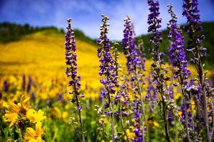
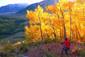
Mule’s ears sunflowers and larkspur in Brush Creek
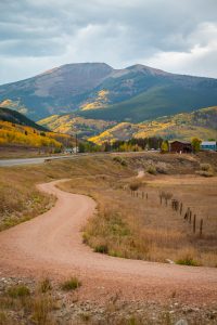
Scenery around Brush Creek
If you’re looking for a hotspot for Crested Butte’s famous summer wildflowers or golden fall aspen leaves, the Brush Creek mountain bike trails deliver both. Wildflowers peak in July; aspen leaves change color in September.
Things to do in Brush Creek
- Go fly fishing on the East River off Brush Creek Trail—please respect private property!
- Ride a dirt bike on the Teocalli Ridge trail or the 409s
- Camp at a designated site on Brush Creek or Farris Creek road
- Hike the Brush Creek trail
- Golf at Skyland Lakes
- Hike or backpack to Twin Lakes
- Paddleboard the Slate River
Other trail areas in Crested Butte and Gunnison
Looking for more MTB ride ideas around Crested Butte? Check out these other trail areas:
