Crested Butte town trails
Discover hiking and biking trails close to town in Crested Butte:
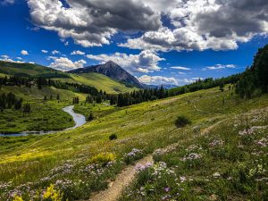
Crested Butte town trails offer easy access to scenic hiking and mountain biking right from downtown, with no car required. These beginner to intermediate trails deliver a surprisingly remote feel, featuring river corridors, wildflower meadows, aspen groves and classic mountain views just minutes from town.
- Ride or hike directly from downtown on the Lower Loop, Lupine, Baxter Gulch, and the Crested Butte Rec Path.
- Beginner-friendly options with a few advanced routes like the Baxter-Carbon-Green Lake loop.
- Excellent scenery year-round, from summer wildflowers to fall aspens and winter Nordic skiing.
______________________________________________________________________________________
Crested Butte is surrounded by some of Colorado’s most beautiful trails, and some of them are accessible right from town. This guide to the Crested Butte town trails will help you design mountain biking or hiking routes that start in or close to the downtown district. If you start in Crested Butte, you don’t need a car to get to any of the trails in this area. The Crested Butte town trails provide a surprisingly remote wilderness experience, especially considering how close to town they are. Many are near water, including the Slate River and Peanut Lake. Most of them are rated beginner to intermediate.
Where are the Crested Butte town trails?
The Crested Butte town trails are the trails that are rideable (or walkable) from downtown Crested Butte, Colorado. The town of Crested Butte is located on the west side of Highway 135, 28 miles north of Gunnison. The Crested Butte town trails include:
Crested Butte town trails map
Drag and zoom around the map below to find the trails featured in this article. Click on a trail for more details.
Best Crested Butte town trails
The Lower Loop
Lower Loop trail system
Lower Loop trail system stats
All Lower Loop trails are suitable for beginners. The Lower Loop trail system consists of
- Lower Loop: 2.8 miles
- Upper Lower Loop: 1.5 miles
- Woods Walk: .7 mile
- GB Loop: .9 mile
- Budd: 1.3 miles
Lower Loop trail system overview
The Lower Loop trails are easy—perfect for kids and beginners. Although these trails are close to town, they quickly enter public land, providing a true wilderness experience. The Lower Loop is popular for both hiking and mountain biking.
Where is the Lower Loop trailhead?
The Lower Loop town connector trail begins at the west end of Teocalli Avenue in downtown Crested Butte. There is another access point with limited parking about 1.5 miles up Peanut Lake Road. Woods Walk also begins about a quarter mile west town where Whiterock Avenue turns into County Road 12 (the Kebler Pass road).
Lower Loop trail description
The Lower Loop trails are the closest trails to Crested Butte. Lower Loop runs northwest out of town, following the Slate River valley in and out of aspen groves. Take in views of Peanut Lake, Crested Butte and the Slate River as you pedal along this easy trail. Lower Loop is a vital part of many popular MTB routes, providing a convenient ending to many rides. Take Lower Loop back into town after riding Lupine or Gunsight Connector. Wildflowers flourish here in summer. The thick aspens along the trail also make it a great fall ride.
Crested Butte Rec Path
Crested Butte rec path stats
- Distance: 5 miles
- Skill level: Beginner (paved)
Crested Butte rec path overview
The Crested Butte rec path connects the towns of Mt. Crested Butte and Crested Butte. This wide, paved trail is ADA accessible.
Where is the Crested Butte rec path trailhead?
The south end of the trail starts at the east end of Elk Avenue in Crested Butte. The trail culminates at the Snodgrass trailhead in Mt. Crested Butte (two miles north of the bus circle and Crested Butte Mountain Resort).
Crested Butte rec path description
The rec path separates pedestrian and bike traffic from cars on the journey between Crested Butte and Mt. Crested Butte. It’s also a piece of many popular mountain biking loops in the area. Use the rec path to access the Lupine or Snodgrass trails from town. One popular route is to take the rec path north out of Crested Butte, ride west on Lupine trail and Gunsight Connector, then take Lower Loop back into town. You can make a similar loop with the Snodgrass trail, too.
Lupine trail
Lupine trail
Lupine trail stats
- Distance: 3.7 miles
- Skill level: Beginner/intermediate
Lupine trail overview
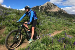
This moderate trail climbs west up the Slate River valley before quickly descending to Slate River Road. Lupine is one of the most popular mountain bike trails in Crested Butte. Lupine wildflowers bloom on the hillsides around the trail in June and July.
Where is the trailhead for Lupine trail?
The Lupine trail starts in the Saddle Ridge development approximately two miles north of the town of Crested Butte. The trail starts on the west side of Highway 135 (Gothic Road) at the Saddle Ridge sign. THERE IS NO PARKING HERE. Please help keep this trail accessible by following the rules!
Lupine trail description
Lupine is a Crested Butte classic. This trail is not to be missed during wildflower season! The recommended route for Lupine is to start in town and ride up the rec path to the Lupine trailhead. Ride Lupine, then take Gunsight Connector and/or Lower Loop back into town. The Lupine trail itself starts with a steep climb through a meadow. Then you’ll ride through groves of aspens as the trail flattens out. Traverse the ridge and enjoy the view of the Slate River for a mile or two. There are two choices for a downhill: ride down the Lupine trail to Slate River Road, or keep traversing the ridge and ride down Gunsight Connector. The Gunsight Connector route will drop you onto the Lower Loop trail system. Snodgrass trail, which starts in Mt. Crested Butte, is also often linked with Lupine and Lower Loop for a 23-mile ride.
Baxter Gulch trail
Baxter Gulch, Carbon and Green Lake loop
Baxter Carbon Green Lake stats
- Distance: 17 miles
- Skill level: Advanced/expert
Baxter Carbon Green Lake overview
Link Baxter Gulch, Carbon and Green Lake trails for an epic, high-altitude ride through the backcountry west of Crested Butte.
Where is the trailhead?
The trailhead for Baxter Gulch trail starts less than half a mile south of Crested Butte on the west side of Highway 135. There is a very small parking lot with a map and sign. The best way to ride this loop is to start in town, since that’s where the Green Lake trail ends.
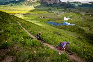
Baxter Carbon Green Lake trail description
Start by climbing Baxter Gulch trail. This six-mile trail is a sustained uphill route that parallels the pretty creek between Mt. Axtell and Whetstone Mountain. This climb isn’t technical, and conifer trees provide ample shade. Turn right (north) onto Carbon trail. This section of the Carbon trail is sometimes referred to as Para Me Y Para Te. The high elevation combined with large chunks of granite make this trail challenging but scenic. After three miles you’ll reach the junction with Green Lake trail. If you’re up for a side mission, leave your bike here and turn left onto the Green Lake trail. Follow this short spur to Green Lake, a crystal-clear alpine lake tucked into the shadow of Mt. Axtell. Return to your bike and ride the blisteringly steep, rocky eight miles back into Crested Butte. The trail ends behind the Big Mine arena on the southwest side of town.
Scenery around the Crested Butte town trails
The town trails teem with wildflowers in spring and early summer. They’re also a hotspot for leaf-peeping in September and October when the aspen leaves change color. You might spot wildlife or birds around Peanut Lake. Moose are a common sight along the Slate River. Mountains surround these trails in every direction. Iconic views of Mineral Point, Red Lady (Mt. Emmons) and Gothic Mountain can be accessed from the Lower Loop and Lupine.
Other things to do in downtown Crested Butte
Crested Butte is a charming, picturesque town filled with cool shops and one-of-a-kind restaurants. You’ll find many choices for places to eat before and after your ride. There are several small bed-and-breakfast-type lodging options in Crested Butte. Larger hotels can be found just four miles up the road in Mt. Crested Butte. Live music and festivals are common occurrences. Check the events calendar to see what’s happening.
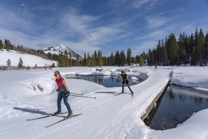
Nordic skiing on the CB Nordic trails
Winter trail use
Access to Woods Walk and Lower Loop changes in winter due to agreements with private landowners. Some of the Lower Loop trails are also groomed for cross-country skiing and require a CB Nordic pass. Check out this guide to winter vs. summer trail use in Crested Butte for more details.
Other trail areas in Crested Butte and Gunnison
Looking for more trails in one of the world’s best places for mountain biking? Here are a few other spots in the Gunnison Valley with high concentrations of trails:
- Taylor Canyon
- Gunnison National Forest
- Signal Peak
- Cement Creek
- Crested Butte classic trails
- Brush Creek
- Hartman Rocks
- Crested Butte Mountain Bike Park
Can’t decide where to start? Visit the main mountain biking page for an overview of the Gunnison Valley’s trail offerings.
