Trip Itinerary: Three Days of Hiking in the Gunnison Valley
Plan a Colorado hiking trip with this three-day itinerary for a trip to the Gunnison Valley:
This blog outlines a flexible three-day hiking itinerary in Colorado’s Gunnison Valley, showcasing diverse landscapes from high alpine peaks and wildflower meadows to high desert rock formations. With uncrowded trails, varied terrain, and great food towns nearby, it’s an ideal destination for both casual hikers and experienced adventurers.
Day 1: Easy acclimation hikes near Crested Butte (Lower Loop, Woods Walk) plus dining, shopping and events on Elk Avenue
Day 2: Choose your adventure with scenic wildflower hikes (Rustler Gulch), peak bagging (Gothic or Crested Butte Mountain), or a challenging lake hike (Copper Lake)
Day 3: Explore high desert terrain at Hartman Rocks or canyon and reservoir views at Curecanti National Recreation Area
Best seasons: Summer and fall offer mild weather, peak wildflowers and fall foliage
Getting around: Fly into Gunnison-Crested Butte Airport and use a car, free transit, or shuttles to access trailheads
______________________________________________________________________________________
With 1,200+ miles of hiking trails, the Gunnison Valley offers many opportunities for day hikes—enjoy three days of exploring different trails from the comfort of your hotel or vacation rental and the amenities in town. Take in sweeping 360-degree views after climbing a mountain in the high alpine or explore trails dotted with large rock formations in the high desert. Trails wind through wildflower meadows, canyons, dense forests, and past wildflowers and lakes. Practically never-ending miles and a wide range of natural settings make the Gunnison Valley a hiker’s paradise. Use this sample trip itinerary to help plan three days of hiking in the Gunnison Valley.

Why hike in the Gunnison Valley?
The Gunnison Valley is made up of diverse environments. Exploring different landscapes and seeing a variety of views in one trip is easy. Gunnison’s environment is characterized by funky rock formations and high desert vistas. Find yourself wandering through sagebrush fields and the tops of remote plateaus. Compared to other Colorado destinations such as Aspen or Rocky Mountain National Park, the trails in the Gunnison Valley don’t tend to get very congested. You’ll find a wider variety of terrain and ecosystems than in places like Estes Park, Salida or Colorado Springs.
High peaks dominate the north end of the Gunnison Valley. Expect sweeping views, colorful wildflowers, winding rivers and tall trees on north valley hikes. It’s an easy half-hour drive or 40-minute bus ride between Gunnison and Crested Butte. Looking for more inspiration about hiking in the Gunnison Valley? Discover 10 reasons to hike here.
When is the best time to hike in the Gunnison Valley?
Hiking season usually begins in Gunnison in April because Gunnison sits at a lower elevation than Crested Butte. By May, many low elevation trails in Crested Butte are ready for hikers. High alpine trails usually melt out by late June, but this varies based on snowfall. Summer and fall offer the best hiking in the Gunnison Valley. Both seasons offer mild weather and stunning views.
Getting here
Make the most of your time on the trails and fly to Gunnison-Crested Butte Regional Airport! Flights arrive and depart daily from Gunnison-Crested Butte Regional Airport (GUC), making it easy to get here. Get around the valley with a rental car, the free public transportation, or hire a shuttle for trailhead pickups and drop-offs.
What is included in this hiking trip itinerary?
This sample three-day hiking trip itinerary will help you plan a Colorado hiking trip. This itinerary has route suggestions for a variety of hikes. We’ve also included some things to do in town after hitting the trails. Lastly, find tips to follow for a fun and safe hiking trip.

Day 1
After settling into your lodging, go on a short hike to get used to the altitude. The town of Crested Butte’s elevation is 8,865’, with surrounding peaks rising to 13,000’.
Lower Loop offers an easy, low elevation hike close to town with amazing views. Stroll the mellow path while taking in views of the Slate River Valley and Paradise Divide. Benches along the trail make it easy to take breaks and soak in the scenery. Do the whole seven-mile loop, or turn around at any time.
Other easy hike ideas:
Long Lake – 1.8 miles out and back
Woods Walk – 2.9 miles out and back
Recreation Path – 4-mile paved loop
Visit Elk Avenue in Crested Butte
In the evening, grab a drink and dinner in downtown Crested Butte. Check our events calendar to look for events such as live music, trivia, historic walking tours, art classes or gallery openings. Pop into Crested Butte’s shops and galleries to look for souvenirs.
Day 2
Today is the day to go on a longer or more challenging hike. Get an early start with breakfast and coffee in town before heading to the trailhead. Learn about options for different kinds of hikes below.

If you’re looking for a scenic hike, try Rustler Gulch:
This moderate nine mile out and back hike provides incredible mountain views and abundant wildflowers. Expect a long but not strenuous journey and views the whole way. Begin in a wildflower dotted meadow. About ¾ of a mile in there is a creek crossing. Once you cross the creek, the trail becomes rocky and heads towards jagged red rocks.
The trail curves into the gulch and runs parallel to a stream. Precarious Peak stands tall over the meadow in the distance. See wildflowers, peaks and waterfalls on this hike. As an out and back, you turn around and head back to the trailhead at any point. Drink in the views of Gothic Mountain on the way back to your car.

If you’re looking for a challenging hike, try Gothic Mountain:
Gothic Mountain is part of the Elk Mountains in Gunnison National Forest. This short but strenuous hike is about 3.85 miles. Drive up Gothic Road from Crested Butte for 1.75 miles to Washington Gulch Road. Turn left past the ghost town Elkton and drive for about eight miles to the trailhead. Begin on Trail 403 surrounded by wildflowers.
The trail eventually switchbacks up the hillside. Look west for views of Mt. Baldy. After this, the trail swings east and provides views of Washington Gulch. Continue to a trail junction where you’ll turn right. At the next junction, go right to continue.
The trail heads downhill for .7 miles to another junction where you’ll turn right (south) towards Gothic Mountain. Go over a marshy section and continue uphill through a forested area. Once the trail exits the woods, it becomes steep. Climb up the main ridgeline and past the treeline to the first false summit. Take a break at the second false summit to enjoy the view before following the well-defined trail to the saddle and up to the true summit.
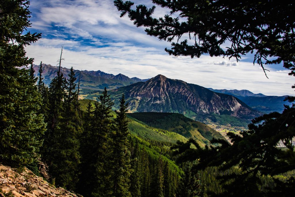
If you’re looking to bag a peak, try Crested Butte Mountain:
Hike to the top of this iconic pointy peak. Start hiking at the base area of Crested Butte Mountain Resort or purchase a lift ticket for the Silver Queen Lift for a shorter hike. From the base area, begin on Up and Away Trail. This trail climbs to Painter Boy Road, where you’ll go left to Painter Boy Lift. Continue climbing up the road to a junction with a large trail map.
Take the trail Primer and hike up to Red Lady Lift. From there, get on Upper Mountain Access Trail. This trail switchbacks from Red Lady Lift to Silver Queen Lift. At the Silver Queen Lift, head left and walk up the wooden steps through the forest. Eventually, the trail goes above treeline and gets steeper.
Follow the trail to the right before climbing a steep slope. Be prepared to scramble through the boulders that create the summit. The top of the hike features plaques, memorials and prayer flags. Your 9.9 out-and-back hike is rewarded with 360-degree views from 12,162 feet.
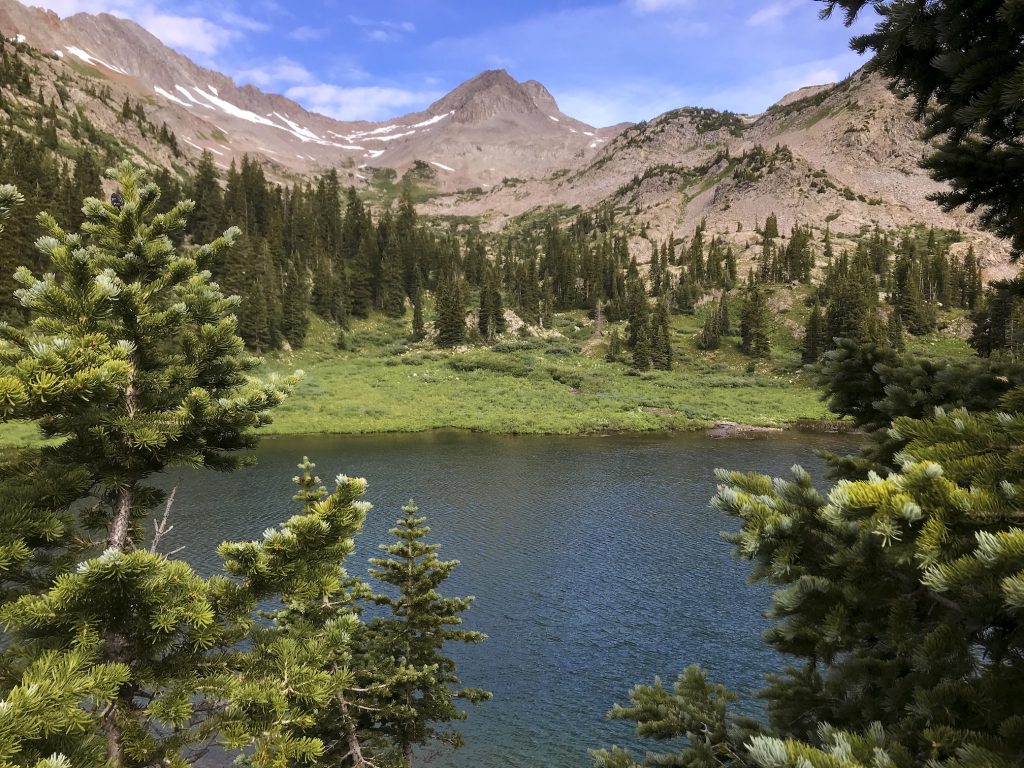
If you’re looking for a lake hike, try Copper Lake:
This challenging hike is about 10.2 miles out and back. Take Gothic Road from Crested Butte for a little over eight miles to the town of Gothic. Park at the Copper Creek lot on the right side. Follow the trail up to Judd Falls for about a mile. Keep going past the waterfall for 1.4 miles to a creek crossing.
Continue hiking through a thick spruce forest for 1.4 miles to a second creek crossing. A third one follows quickly. A mile after the third crossing, go straight at the junction. In .2 miles, arrive at the bright-blue lake surrounded by rocky mountain peaks.
Dining in Crested Butte
Grab a hearty and delicious meal after a day on the trails! Crested Butte dining options include award-winning pizza, family-style fried chicken, inventive Asian fusion and farm-to-table fare. Enjoy with a pint of beer brewed right in town or a craft cocktail made with local spirits.
Day 3
Head to Gunnison on your last day for a hike in the high desert. Hartman Rocks Recreation Area is a high desert recreation mecca. 40-plus miles of trails, sage-covered hills and wide-open views dotted with large rock formations give a lot of hiking options. Read about some of the best hiking trails at Hartman Rocks.

Find Curecanti National Recreation Area west of town. Most of the hikes in Curecanti have views of Blue Mesa Reservoir, Colorado’s largest lake. Volcanic formations and deep canyons characterize the trails in Curecanti. Browse hikes on the Curecanti website.
Visit Gunnison
Head to Main Street in Gunnison after hiking to grab a bite to eat and do some shopping. Gunnison dining options include pizza at the brewery, traditional Greek pita dishes, authentic Himalayan food and elevated American fare.
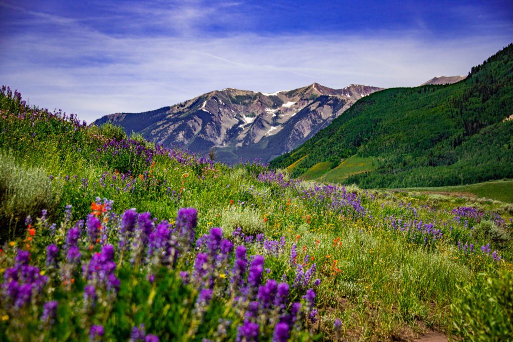
Wildflower hikes in Crested Butte
Colorado officially designated Crested Butte as its Wildflower Capital. July and August bring forth spectacular colors and shapes to the Gunnison Valley. If you’re looking for hikes with excellent wildflowers, try these routes:
Brush Creek Trail – Easy, 4.29 miles out-and-back
Snodgrass Mountain Trail – Moderate, 7.2 miles out-and-back
Woods Walk – Easy, 2.9 miles out-and-back
Lupine Trail – Moderate, 7 miles out-and-back
Fall hikes in the Gunnison Valley
Experience the magic of fall in the Gunnison Valley. The aspens turn shades of gold, red and orange, an incredible sight to behold. Some of the best fall hikes in the Gunnison Valley include:
Oh Be Joyful – Challenging, 13 miles out-and-back
Beaver Ponds – Easy, 1.1 miles out-and-back
3 Lakes Loop – Easy, 3-mile loop
Green Lake Trail – Moderate, 8.5 miles out-and-back

How to prepare for a hiking trip
Going on hikes and walks at home can help your body work the proper muscles for hiking. Start hydrating before you get here and keep it up after you arrive.
What to bring on a Crested Butte day hike:
- Plenty of water and snacks
- Sunscreen, a hat and long sleeves for sun protection
- A mid-weight layer and rain jacket
- A map
- Sandals such as Tevas or Chacos for water crossings
For even more trails, maps and hiking tips, visit our Gunnison Valley hiking guide.
Plan your trip
Now that you’re thinking about all the amazing trails you can hike in the Gunnison Valley, start planning your trip! Our trip planning guide has information about booking flights, finding a place to stay and choosing things to do in one handy place.
Frequently asked questions about hiking in the Gunnison Valley
- When is the best time to hike in the Gunnison Valley?
Summer (June–August) offers full trail access, wildflowers, and long days.
Fall (September–October) features cooler temps and stunning golden aspen foliage.
- Are maps or apps recommended?
Yes! COTREX, AllTrails or Gaia GPS are a few apps you could use. Download offline maps—cell service can be limited in remote areas. Trail maps can also be purchased in gear shops and bookstores.
- What wildlife should I be aware of?
You might see deer, elk, marmots, black bears or moose.
- What’s the altitude like?
Crested Butte sits at 8,885 feet, and some hikes reach over 12,000 feet. Take it slow, stay hydrated, and allow time to acclimate if you’re coming from lower elevations.
- What should I pack for a hike?
Essentials: Water, snacks, layers, map/GPS, sun protection.
Extras: Rain jacket, trekking poles, bear spray.
Be prepared for fast-changing weather, even in summer.
- Where can I park for hikes?
Many trailheads (like Judd Falls or Brush Creek) offer designated parking areas. Park in designated parking areas whenever possible. If there is no designated parking area, park completely off the roadway. Do not park on private land. Do not drive off designated routes or through meadows.
- Can I drink from streams or lakes?
Not without filtration or purification. Even the clearest alpine lakes can contain bacteria.
- Are dogs allowed on trails?
Many trails are dog-friendly. Research specific trails ahead of time to learn about leash laws for each area. Always pack out pet waste.
- Are there guided hikes available?
Yes! Learn more about guided hiking in the Gunnison Valley.
More hiking information
Discover more about hiking in the Gunnison Valley with our guide to 10 Reasons to Hike in the Gunnison Valley. Find a scenic Colorado hike. Explore more lake hikes.
