Hartman Rocks Trail Running
Check out Hartman Rocks in Gunnison, Colorado, for trail running routes:
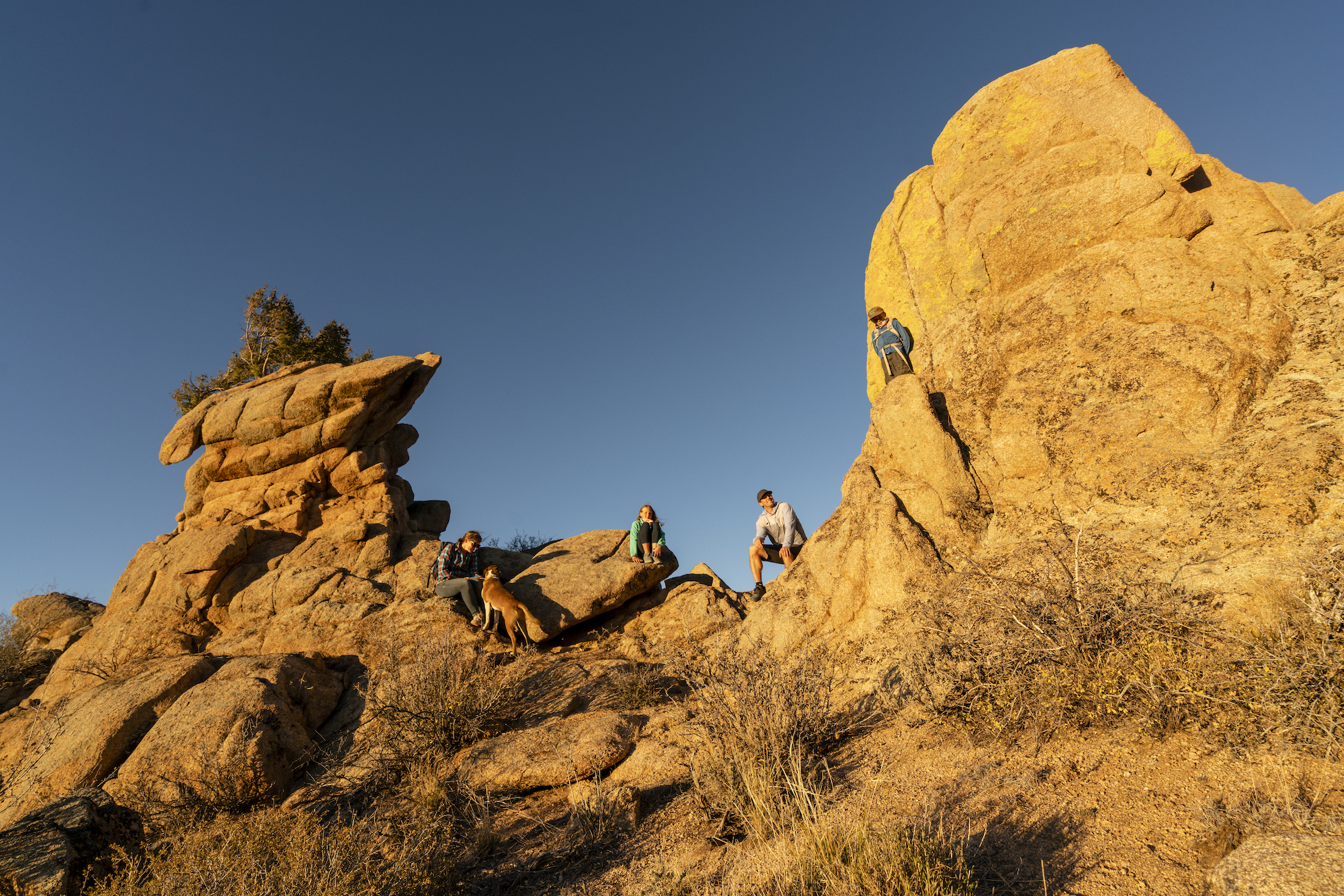
Hartman Rocks Recreation Area near Gunnison is a high-desert trail running destination with over 40 miles of varied terrain, from smooth, flowy singletrack to steep, technical climbs. Open spring through fall, it offers wide-open views, unique rock formations and flexible route options for runners of all levels.
- Located just 15 minutes from downtown Gunnison, with multiple access points and parking areas.
- Best trail running in spring, summer and fall. Mornings and evenings are ideal due to sun exposure.
- Popular routes include Graceland Trail, Gateway Trail and Aberdeen Loop West, with easy trail connections for longer runs.
- Elevation around 8,000 feet adds a fitness challenge; bring plenty of water and sun protection.
- Dog-friendly, with restrooms, picnic areas and shared-use trail etiquette to follow.
______________________________________________________________________________________
Discover your new favorite trail run at Hartman Rocks Recreation Area. This high-desert playground in Gunnison might be known for mountain biking, but it’s also an incredible setting for trail running. The 40+ miles of trails, wide-open views and striking rock formations offer much to explore. Keep reading to learn more about trail running routes at Hartman Rocks.
What is Hartman Rocks?
With over 8,000 acres of land, Hartman Rocks is a recreation paradise. Whether you’re looking for gravel roads, singletrack, hiking trails or rocks to climb, find it at Hartman Rocks.
Where is Hartman Rocks?
To get to the main entrance:
Hartman Rocks Recreation Area is only a 15-minute drive from downtown Gunnison. Head west on Highway 50 from downtown Gunnison. Before crossing the Gunnison River, turn left on Gold Basin Road (CR 38). Continue on Gold Basin Road for about 2.8 miles until reaching the Hartman Rocks entrance sign on the west side of the road.
To get to the back entrance:
The back entrance of Hartman Rocks is called McCabe’s. Head west on Highway 50 from downtown Gunnison. After four miles, turn left onto to CR 32. There will be a turnoff just past a gravel pit after about 1.5 miles. Continue for about .5 miles past the motorcycle jumps, and park in the large lot by the pit toilet.
When is the best time to trail run at Hartman Rocks?
Spring, summer and fall are the best seasons for Hartman Rocks trail running. Trails at Hartman Rocks usually open for the season in April and stay open until snow accumulates on the ground. Because Hartman Rocks offers little shade, runners find mornings and late afternoons the best times to explore the trails. Afternoon thunderstorms are common in the mountains, so come prepared with a rain jacket during July and August.

Trail running at Hartman Rocks
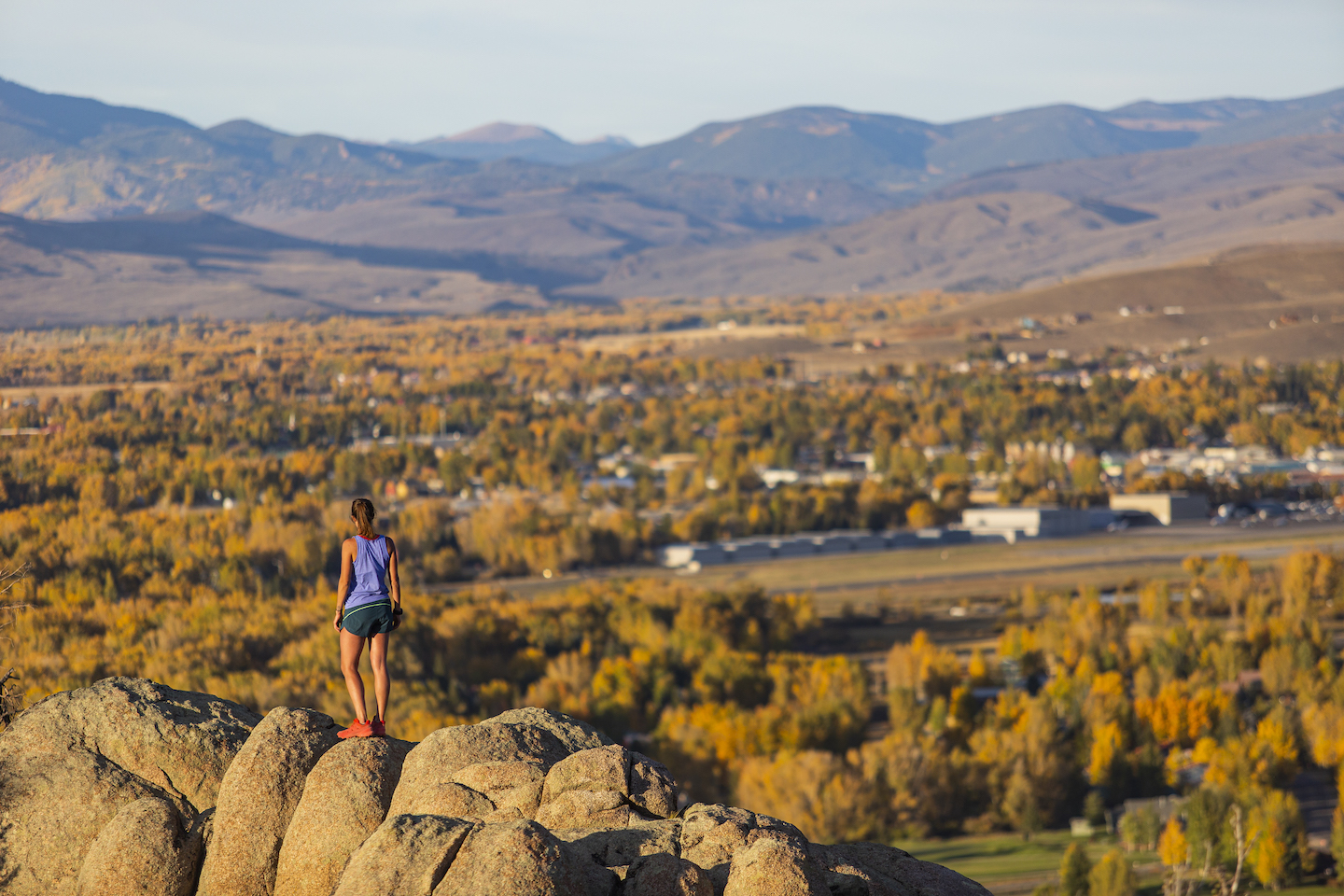
The endless combinations of trails at Hartman’s make it easy to plan a Hartman Rocks trail running route of any distance. Check out steep, rocky and technical trails like Rocky Ridge and Graceland for a challenge. Or discover something flowy and smooth that cuts through fields of sagebrush, such as The Luge or Five-O. At an elevation of around 8,000’, Hartman Rocks offers a challenge for your lungs and legs. Make sure you have plenty of sunscreen and water before hitting the trail!

Trail running routes at Hartman Rocks
Graceland Trail – Moderate, 3 miles
Graceland Trail starts on the northwest side of Hartman Rocks, across the road from Gateway. Run Graceland Trail clockwise for more of a descent. For a longer climb, run it counterclockwise. Rock features and switchbacks require sharp focus on your footwork.
Gateway Trail – Moderate/challenging, 2.3 miles
This Hartman Rocks trail running route offers a mix of smooth, intermediate terrain mixed with short technical sections. An average grade of 4% with sections reaching up to 20% provides trail runners with a mix of challenging and mellow sections.
Aberdeen Loop West – Moderate, 3.4 miles
This winding trail is one of Hartman Rock’s longest. It’s best run counterclockwise, but either direction works. Runners looking for a high desert cross-country experience will love this trail. It is not very technical, but the remote-feeling wide open sage country is a beautiful setting for a long run. As you run along the ridges, take in views of the San Juan Mountains to the southwest.
Other top trail running routes at Hartman Rocks
- Rocky Ridge
- Rattlesnake
- Beck’s
- Top of the World
- Josie’s
What amenities does Hartman Rocks have?
Bathrooms are situated at the main parking areas and throughout the area. A handful of picnic areas make for great resting spots.
Does Hartman Rocks have parking?
Multiple parking areas make it easy to visit Hartman Rocks. There is parking at the front and back entrances of Hartman Rocks. There is also parking at the top of Kill Hill. Limited parking is available at the trailhead for Bambi’s, which is south of the main parking lot.
Is Hartman Rocks dog-friendly?
Dogs are allowed at Hartman Rocks but must be leashed or under verbal command. Make sure you pick up after your pet, too.
Tips and trail etiquette for trail running at Hartman Rocks
Share the trail! While running, be mindful of other trail users. Keep these tips in mind when using the trails at Hartman Rocks:
- Uphill runners and hikers have the right of way. Downhill runners and hikers should move off the trail to let uphill travelers pass. Bicyclists should yield to runners and hikers. Runners and hikers yield to horses and pack stock.
- Only run on the designated trail to avoid damaging vegetation.
- Maintain distance from wildlife.
- Don’t run on muddy or wet trails. If you encounter mud, turn back or go through it (rather than around it) to avoid damaging the trail.
- Make sure you’re prepared with plenty of water, snacks and layers.
- Shade is sparse at Hartman Rocks. Wear a hat and sunscreen to protect yourself from the sun.
- Obey trail closures.
Other places to trail run in Gunnison
Dillion Pinnacles Trail – Easy, 3.8 miles out and back
This trail is in Curecanti National Recreation Area. Head west on Highway 50 from Gunnison for about 21 miles. The trailhead is on the right side of the road right before the bridge. Get a run in with views of Blue Mesa and the Dillion Pinnacles. The pinnacles are towering volcanic formations eroded from West Elk Breccia.
This trail is pretty mellow with some steeper uphill sections. The first section of the trail is flat and heads in the direction of Blue Mesa. About 3/4 of a mile in, the trail heads towards the pinnacles. A mile in there is a draw shaded with cottonwoods, juniper, oak brush and ponderosa pine. Go left after the draw and climb the trail to face the pinnacles. Follow the trail under the pinnacles in and out of drainages. Keep following the loop back to the trailhead.
Van Tuyl Trail – Easy, 3.1-mile loop
This well-maintained trail is located in Gunnison near CharMar Park. The trail is packed gravel and fairly flat with a small gradual incline. Take in views of the Gunnison River, W Mountain and the Palisades on your run. The loop is well signed and easy to navigate. Run the whole loop or turn back at any point.
Signal Peak Loop – Moderate, 9.1-mile loop
Signal Peak is located across the road from the ICELab @ Western. These trails are right in town and are easily accessible. Head up the Contour Trail to join the South Rim Trail. The initial climb is gradual. At about 3.5 miles in, take the Chicken Wing Trail to continue climbing.
At the top, the trail merges onto Signal Peak Trail. This is one of the highest points of the loop and offers beautiful views while trail running. Descend Duane’s World before connecting to the west leg of the Contour Trail back to the trailhead. The whole trail is exposed, so wear sunscreen and bring plenty of water.
Plan your trip
Find all the resources you need to start planning a Hartman Rocks trail running trip with our trip planning guide. Book flights, research restaurants, plan things to do and check local conditions.

Find a place to stay in Gunnison
Camping at Hartman Rocks is first-come, first-served and fills up quickly in the summer and fall. Those coming from out of town will have better luck booking a campsite at a campground that takes reservations. Better yet, treat yourself to a comfy bed and shower by booking a hotel or vacation rental.
More trail running information
This hiking information can also help trail runners plan routes. Start planning a hiking trip with our sample hiking trip itinerary. Discover more scenic Colorado hikes in the Gunnison Valley. Looking for more reasons to hike in the Gunnison Valley? Here are 10 reasons to hike in the Gunnison Valley.
