Taylor Canyon trail guide
The east-central side of Colorado’s Gunnison Valley encompasses Taylor Canyon, Taylor Park, Spring Creek and the tiny town of Almont. Anglers, mountain bikers, hikers, campers and OHV enthusiasts share this massive swath of Gunnison National Forest. The mountain biking hotspot in this area is the Doctor Park trail, which runs between Spring Creek and Taylor Canyon, but there’s so much more to explore in the area than just that. This guide describes the Doctor Park ride in detail and provides ideas for other things to do in Taylor Canyon. Check out the map below to help plan a trip to this ruggedly beautiful area.
Doctor Park
About Doctor Park trail
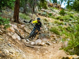
Doctor Park Trail #424 is one of the world’s most beloved mountain bike trails. It ranks among classics like the 401 just up the road in Crested Butte, Colorado, The Whole Enchilada in Moab, Utah, Hiline in Sedona, Arizona, and the Downieville Downhill in Downieville, California. Doctor Park is rated expert due to its steepness, technicality and length.
Doctor Park trail conditions
In spring, the ridgetop at the high point of Doctor Park trail can hold snow and mud. Check Crested Butte Mountain Bike Association’s trail conditions page before you ride to make sure the trail is passable.
Parking for Doctor Park
Most mountain bikers ride Doctor Park as a loop. Park at North Bank Campground, located on County Road 742 (the Taylor Canyon road) about eight miles east of Highway 135. There is limited parking at the campground. Three additional public parking lots are available on CR 742 just west of the campground.
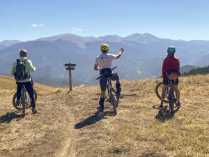
Doctor Park loop route
Distance: 19 miles
Ability level: Advanced/expert
From North Bank Campground, ride west on CR 742 for less than half a mile. Turn right on County Road 744 (Spring Creek Road). CR 744 is unpaved but regularly graded. Climb up the steep but scenic canyon road for nine miles. Here, cross Spring Creek, which can be waist-deep during spring runoff. Get ready for more cranking up Doctor Gulch Road, a steep 4×4 road that climbs three miles to the top of the ridge.
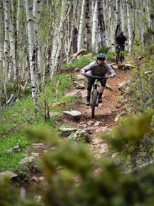
Now the fun begins! Doctor Park trail starts in dark timber. Pedal for about a mile through the trees before reaching a spectacular meadow. Take in the views before embarking on the downhill section. It starts off chunky and steep, with loose rocks and medium-sized drops. Then, the trail descends into a grove of aspen trees that hold even more rocky fun.
The next portion is known as “Jedi Mind Tricks,” because you’ll move at lightspeed through this smooth, flowy trail section. Catch your breath before crossing a burn area with smooth rock features and another stunning view.
The final part of the trail is perhaps the most difficult. About a dozen tight switchbacks lead down the canyon towards the Taylor River. Maneuvering through the many small boulders here proves technically challenging, and a steep dropoff makes for high consequences. Elite riders should explore the expert line on the large boulder at the last switchback. The trail terminates at North Bank Campground.
Doctor Park route options
Doctor Park Bonus
Want to add a couple more miles to the ride? Tack on Doctor Park Bonus trail for a little more mileage and a beautiful vista. Turn left onto Doctor Park Bonus in the dark timber near the top of the ridge. The trail juts north before circling back to join up with the main trail in the first meadow.
Driving a shuttle
Some riders choose to run a shuttle on the Spring Creek Road segment. This cuts the ride distance down to ten miles.
Doctor Park trail map
The Doctor Park trail is shown on the map below. Zoom out for a big-picture view of more trails in Taylor Canyon, Spring Creek and Taylor Park.
Crested Butte on Trailforks.com
Reno-Flag-Bear-Deadman
Although the Reno-Flag-Bear-Deadman mountain bike route begins and ends on Cement Creek Road, Bear Creek Trail is also accessible from County Road 744, also known as Spring Creek Road. Drive north on CR 744 past Spring Creek Reservoir to access Bear Creek from the top. Bear Creek is sometimes combined with Doctor Park to make a longer ride. Avid riders may choose to embark on Reno-Flag-Bear-Doctor-Deadman, an elite, 40-mile sufferfest through some of the Gunnison Valley’s best trails.
OHV
Dirt bikes are a common sight on Reno, Flag, Bear, Deadman, Rosebud, Star and the upper part of Doctor Park trail. 4×4 enthusiasts also enjoy exploring the two-track roads between Taylor Park and the Collegiate Peaks Wilderness. This area is chock-full of mining history, and it’s easy to stumble upon a ghost town tucked into the hillside.
Taylor Park
Taylor Park is the nexus of OHV activity in the Gunnison Valley. 4×4 roads offer miles of fun for side-by-sides, and a large network of motorized singletrack trails provide endless opportunities for exploration by dirt bikes. This guide to Taylor Park walks you through lodging amenities and other things to do in this scenic area near Taylor Reservoir.
Hiking in Fossil Ridge Wilderness Area
Fossil Ridge Wilderness, which is part of Gunnison National Forest, is usually accessed through Pitkin and Ohio City, but there are a few access points in Taylor Canyon as well. The eight-mile trek to Henry Lake starts in Lottis Creek Campground and is popular with backpackers. Summerville Trail #430 is a less-traveled avenue into Fossil Ridge Wilderness. Mountain bikes, e-bikes and motorized vehicles are prohibited in National Forest Wilderness Areas.
Camping in Taylor Canyon and Taylor Park
About a dozen National Forest campgrounds are scattered throughout Almont, Taylor Canyon, Spring Creek and Taylor Park. Advanced reservations are available—and recommended—for these popular campsites. For more information on camping in the Gunnison Valley, check out our camping guide.
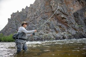
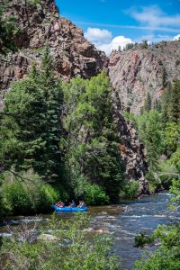
Taylor River
The Taylor River is a small river that begins on the west side of the Collegiate Peaks. The headwaters flow into Taylor Reservoir. Below Taylor Dam, Taylor Canyon begins. The section of the Taylor River that runs through this rugged, rocky canyon is a magnet for anglers and recreational boaters. The Taylor flows about 21 miles from the dam before joining the Slate and the Gunnison rivers in Almont.
Almont
Almont is a tiny community at the confluence of the Taylor, Slate and Gunnison rivers. Cabins ranging from one-room studios to sprawling vacation rentals are available for rent along the river. A few restaurants serve hearty food.
Scenic drives
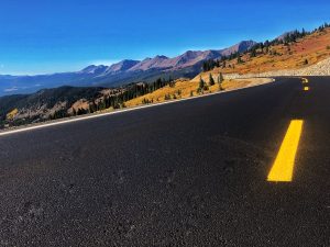
Cottonwood Pass
County Road 742, also known as the Taylor Canyon Road, is a scenic drive in itself. Take in views of the gray, rocky canyon and the cascading river as you wind your way east towards Taylor Reservoir. The road continues east over Cottonwood Pass, one of the highest paved roads in the state. Cottonwood Pass ascends over the Continental Divide and down towards Buena Vista. It is usually open between Memorial Day and late fall.
Jack’s Cabin Cutoff
The Jack’s Cabin Cutoff road, also known as County Road 813, is a four-mile shortcut from Highway 135 to Taylor Canyon. Wildflowers like mule’s ears and lupine bloom here in spring. This road is not paved but is accessible to passenger vehicles.
Other Gunnison Valley trail zones
The trails in Taylor Canyon are just a small slice of the Gunnison Valley’s vast system of backcountry mountain biking and hiking trails.
If you like Doctor Park, explore these other MTB trails during your trip:
- 409.5 in Brush Creek
- Star Pass in Cement Creek
- Rattlesnake in Hartman Rocks
- Chicken Wing in Signal Peak
- Lupine in the Crested Butte town trails


