Cement Creek mountain bike trails
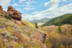
The Cement Creek mountain bike trails are some of the best MTB trails in Crested Butte, Colorado. Crested Butte’s huge network of backcountry mountain biking trails has garnered fame in the world of mountain biking, and the trails in the Cement Creek zone comprise a major part of this network. The Cement Creek area contains everything from short loops to leg-burning epics. Scroll down for a trail map and detailed guide to the best Cement Creek mountain bike trails!
Where is Cement Creek Road?
Cement Creek Road begins on the east side of Highway 135, 6.5 miles south of downtown Crested Butte, Colorado. Maps sometimes refer to Cement Creek Road as County Road 740 and Forest Service Road 740. For clarity, it is called Cement Creek Road throughout this article.
Cement Creek Road generally follows the Cement Creek drainage out of the Elk Mountains to the east. The road is about 15 miles long total. It terminates on a ridge between Crystal Peak and Italian Mountain, about halfway between the towns of Crested Butte and Aspen as the crow flies.
CB South
Nestled in the Cement Creek drainage is Crested Butte South, an unincorporated community of about 1,300 people. This “town” is often called CB South for short. If you’re looking for coffee or a bite to eat after a bike ride, explore the up-and-coming business district on Elcho Avenue. The Gunnison RTA bus conveniently stops in CB South, too.
Cement Creek area trail map
Locate the trails in this article using the map below. Click or tap on a trail for detailed stats. Zoom out to see how the Cement Creek trails tie into the Brush Creek zone to the north and Taylor Canyon to the south.
Cement Creek on Trailforks.com
The best Cement Creek mountain bike trails
Click on a trail name to jump to its description:
Middle Cement loop
Distance: 5.5-mile loop
Skill level: Intermediate with non-mandatory advanced options
This quick ride is perfect for an evening or when you just have an hour or two to ride. The highlight of this loop is the downhill on the section of Middle Cement Creek trail known as Stumpjumper. Start where Lower Cement Creek trail intersects Cement Creek Road. It’s just east of the Caves trailhead. Lower Cement Creek is a mellow, .5-mile warmup under the shade of conifer trees. Turn left onto Walrod Road. Climb up this steep, rocky road up Walrod Gulch for two miles. At the top, take in the view before heading down one of the best bang-for-your-buck descents in the Gunnison Valley. First, ride about a quarter mile down Warm Springs trail. This section is steep and curvy, with a few small drops at the top. Turn right onto Stumpjumper and buckle up! Many creative features are built into this fast section of trail. The stump is near the top of the trail and offers an option for a large jump. Farther down, pick your way through a technical rock garden. Take Lower Cement Creek trail back to where you started.
Reno-Flag-Bear-Deadman
Distance: 18.8-mile loop
Skill level: Advanced
Reno-Flag-Bear-Deadman may have an unwieldy name, but it’s a Crested Butte classic along with the likes of Doctor Park, the 409s and the 401. With three climbs and three descents, this cross-country ride requires a high level of physical endurance. A cool part of this ride is the abundance of nearby water, including Bear Creek and Flag Creek. Be prepared for many splashy stream crossings along the way. This route is open to motos, mountain bikes and hikers. Share the trail with other folks out enjoying this scenic slice of the Gunnison Valley!
Start at the Deadman’s Gulch trailhead on the south side of Cement Creek Road, approximately 7.5 miles east of Highway 135. Ride up Cement Creek Road for two miles, then continue up Italian Creek Road for 3.5 miles. This is the longest climb of the ride. The first descent is Flag Creek, a fun and speedy downhill into a pretty little valley. Another 2.5-mile climb up Bear Creek and West Flag Road gets you to the Bear Creek descent. Grit your teeth for the last climb up the ridge to Deadman’s Gulch trail—it’s a steep one. Ride down about a dozen switchbacks on the last descent, which brings you back to the starting point.
Reno-Flag-Bear-Doctor’s-Deadman
For a true sufferfest, some avid mountain bikers add Doctor Park between Bear and Deadman’s. This almost doubles the distance and exponentially increases the difficulty of the ride. Only experts should attempt this, and it’s a truly epic achievement for those who do. As with all very long rides, it’s best to build up to this over the course of the season.
Waterfall Cutoff loop
Distance: 10.1-mile loop
Skill level: Advanced
Recent trail work in the area has transformed the Waterfall Cutoff loop into one of the most popular new bike rides in the Cement Creek area.
Start by riding up Warm Springs, a steep .75-mile moto trail, or up Walrod Road, which is two miles long and less steep. (Parking is only available at Walrod Road.) Either option takes you to the base of Trail #412, “The Wall.” Hike your bike up this one-mile-long, aptly named trail. Catch your breath, then bear right at the fork to ride Waterfall Cutoff trail, a four-mile jaunt along rocky crags that gently deposits you downhill. Turn left (west) onto Fenceline segment of Middle Cement Creek trail. This mellow, four-mile trail follows a map contour line. It tops off the ride with a pleasant pedal back to the beginning.
Star Pass loop
Distance: 22-mile loop
Skill level: Expert
This is one of the highest-elevation rides in the Crested Butte area. Being above treeline (12,000 feet!) on Star Pass provides excellent views of the surrounding area. It also exposes you to weather, which can change quickly in the mountains.
From the Deadman’s Gulch trailhead, take Cement Creek Road north to Upper Cement Creek Trail. Ride up Upper Cement Creek trail for about 2.5 miles. At the intersection with Hunter Creek trail, hop back on Cement Creek Road before turning left onto Crystal Peak trail. Climb up Crystal to Star Pass. Take Brush Creek trail to Block and Tackle. Close the loop on Upper Cement Creek trail, which you’ll ride back down to where you started.
Cement Creek hiking
Caves
Distance: 1 mile (each way)
Skill level: Intermediate
Only have an hour, and want a great workout? Caves is a steep, switchback-laden trail with a grade that will challenge even athletic hikers. There is nothing technical about this trail—it’s just steep. Start at the well-marked Caves Trailhead on Cement Creek Road. Near the top of the trail, the trees open up to a picturesque view of Red Mountain to the west. Explore the two small caves at the top for a bonus adventure! There are also several bolted sport climbing routes on the crags on the east side of the caves.
Do I need four-wheel drive for Cement Creek Road?
The east half of Cement Creek Road requires four-wheel drive. Starting at its intersection with Highway 135, Cement Creek Road is paved for one mile. Over the course of the next seven miles heading east, the dirt road becomes narrower, steeper and rougher. 4×4 is recommended past the switchbacks at approximately mile eight.
Best time to ride trails in Cement Creek
The Cement Creek drainage lies at a slightly lower elevation than Crested Butte proper, so some Cement Creek trails tend to dry out earlier than Crested Butte trails in spring. Spring trail opening timing depends on snow, but expect Caves and Middle Cement to be some of the first north valley trails to open in the spring. During an average snow year, this will be approximately mid-May. Higher Cement Creek mountain bike trails such as Star Pass usually melt out in late spring or early summer.
Cement Creek is also a beautiful area to ride in fall. The leaves on aspen trees change color in September and October, painting the mountainsides yellow. Snowfall varies by year, but the first snow usually falls near the end of October.
Who maintains the Cement Creek trails?
The Crested Butte Mountain Bike Association—the oldest mountain bike club on the planet—maintains the trails in Cement Creek and beyond. Learn more about what CBMBA does and how you can give back to this legendary organization.
Other things to do around Cement Creek
- Paddleboard the Slate River in spring
- Go fly-fishing on Cement Creek or the Slate River in summer
- Hunt in fall
- Cross-country ski on Cement Creek Road in winter (it’s groomed!)
Other trail areas in Crested Butte and Gunnison
The Cement Creek trail system is huge, but it just scratches the surface of the many diverse mountain biking trails of the Gunnison Valley.
- The Brush Creek drainage lies north of Cement Creek and features even more scenic rides for a range of skill levels.
- The Crested Butte town trails offer easy access and mellow riding.
- Ride 50-plus miles of technical, rocky singletrack at Hartman Rocks in Gunnison.
- Explore Signal Peak, the laid-back and lesser-known trail system in Gunnison that’s also a great spot for a trail run.
- Epic views and rowdy rides await in the Crested Butte backcountry.
- Challenge yourself on rock gardens, berms and jumps in the Crested Butte Mountain Bike Park.
- Buckle up for the famous Doctor Park trail in Taylor Canyon.