Signal Peak recreational trails
Gunnison’s Signal Peak recreational trails are beginner-friendly and easy to get to. Their location adjacent to town makes them an ideal location for an evening mountain bike ride. Explore this trail system, which includes the Campus trails, if you’re seeking beginner to intermediate rides and jaw-dropping mountain vistas.
Where are the Signal Peak trails?
The Signal Peak recreational trails, located on the east side of Gunnison, Colorado, are adjacent to the campus of Western Colorado University. The main trailhead is by the Western football stadium. The BLM manages most of the land in this area. Local nonprofit Gunnison Trails builds and maintains the singletrack. Trails in Signal Peak are open to nonmotorized traffic. E-bikes, dirt bikes and ATVs are prohibited here.
Signal Peak trail map
Use the trail map below to read trail descriptions and plan a route through Signal Peak’s 20-plus miles of trail.
Campus trails
On the west side of the Signal Peak trail system is a group of trails called the Campus trails. As the name suggests, these are the Signal Peak trails closest to the Western Colorado University campus. The Campus trails are Contour West, Cemetery, Canal, Old Car, Zig Zag, Chin Ups and the Flow Track. The seasonal Signal Peak trail closures don’t apply to the Campus Trails. Of all the Gunnison Valley MTB trails, the Campus trails usually dry out fastest. This zone provides excellent spring riding.
What to expect at Signal Peak
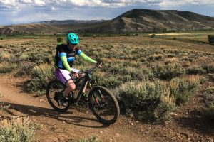
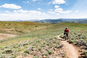
Looking for a mellow pedal in Gunnison? Ride out your door to the Signal Peak trails. They traverse rolling sagebrush hills and are much less rocky and technical than nearby Hartman Rocks. The Signal Peak area is smack-dab in the middle of some of Colorado’s most scenic mountain ranges, including the Sawatch Range, the Collegiate Peaks and the West Elks. From the ridgetops, you even can see the mighty fourteeners of the San Juans to the southwest.
Spring trail closures
Trail closures for wildlife affect the Signal Peak recreational trails in spring. For more information on spring trail closures in Gunnison, see the spring trail restrictions guide.
- The entire Signal Peak area is closed to mechanized use (mountain bikes) from January 1 – April 30, and no use before 10 a.m. May 1-15.
- The entire Signal Peak area is closed to motorized use from January 1 – May 15.
- The northwest portion of the Signal Peak area is closed to all uses (snowshoers, skiers, dog walkers, hikers, bikers) from March 15 – May 15 for sage grouse conservation. This includes the Ridgeline trail from the second radio tower, Rasta Gulch, Chicken Wing, Cranor Hill and Shoelace trails.
Signal Peak recreational trails
Trail runners, hikers, dog-walkers and mountain bikers share the Signal Peak trails.
Mountain biking at Signal Peak
The mountain bike trails at Signal Peak number among the Gunnison Valley’s newest trails. The trails roll over hills and gullies. Expect more of a cross-country style of ride here, rather than the long climbs and sustained descents characteristic of Crested Butte rides.
Mountain bike trails at Signal Peak
- Canal
- Distance: 1.4 miles
- Skill level: Beginner
- This wide trail makes for a pleasant walk or ride suitable for all ability levels.
- Contour (west)
- Distance: 2.6 miles
- Skill level: Beginner
- This trail follows the contour lines of the map. It traverses around a ridge and transports you into the trails on the eastern side of the Signal Peak zone.
- Rasta Gulch
- Distance: .9 miles
- Skill level: Beginner
- When ridden north to south, this curvy trail transports you from the top of the ridge down into a small gully.
- Ridgeline
- Distance: 4 miles
- Skill level: Beginner
- This scenic trail follows the ridgeline on the west side of the Signal Peak area. Take in views of campus and the city of Gunnison.
- Chicken Wing
- Distance: 1.5 miles
- Skill level: Intermediate
- The crown jewel of the Signal Peak trails, this trail is best ridden north to south. The descent is fast, exhilarating and not technical.
- Duane’s World
- Distance: 3 miles
- Skill level: Intermediate
- This winding trail brings you to the far western reaches of the Signal Peak trails, near Signal Peak itself.
- Music Rocks
- Distance: .75 miles
- Skill level: Advanced
- This switchback-filled trail is one of the rockiest at Signal Peak.
- South Rim
- Distance: 2.1 miles
- Skill level: Beginner
- South Rim traverses the upper flank of Signal Peak.
- Shoelace
- Distance: 1 mile
- Skill level: Beginner
- This trail connects South Rim and Chicken Wing, and provides yet another incredible view of the surrounding peaks.
- North Woods
- Distance: 2 miles
- Skill level: Intermediate
- This is the western-most trail in the Signal Peak system. Due to its northern exposure, more trees grow here than anywhere else in the zone.
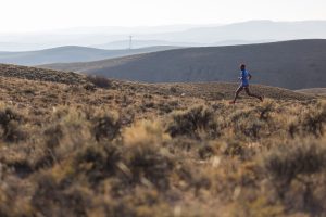
Trail running at Signal Peak
Trail runners commonly recreate around Signal Peak due to the relatively gentle grades of the trails here. Additionally, the Signal Peak trails are less than two miles from the doors of most lodging in Gunnison. For a short, scenic run, start at G Loop. Take that to Old Car; then turn right onto Ridgeline (sometimes shown on maps as Tower Road). Enjoy the views on Ridgeline and head back the way you came. Many longer routes can be made here, too—get creative!
Other things to do in Gunnison
- Work remotely from the ICELab @ Western, a sunny coworking space just steps from the Campus trails
- Hike the scenic Mill-Castle trail
- Ride your gravel bike on County Road 10
- Take a scenic drive through Black Canyon of the Gunnison National Park in summer, or cross-country ski there in winter
About Gunnison
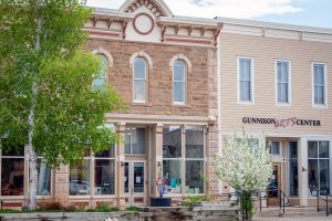
Gunnison, Colorado, population 6,800, is located on Highway 50 halfway between Montrose and Salida. It shares the Gunnison Valley with Crested Butte, located 28 miles north on Highway 135. Western Colorado University had educated students in Gunnison since 1901. Over the last 100 years, Gunnison’s main industries of gravel mining and cattle ranching have given way to outdoor recreation and tourism. Walk the small downtown zone to grab a cup of coffee, peruse an art gallery, get your bike tuned or munch on a slice of pizza.
Other trail areas in Gunnison and Crested Butte
Looking for more MTB trails around the Gunnison Valley? Look at maps and read reports about these other zones:
- Hartman Rocks
- Almont and Spring Creek
- Cement Creek
- Brush Creek
- Crested Butte town trails
- Crested Butte Mountain Bike Park
- Slate River and Washington Gulch
- Gothic and Schofield Pass


