Crested Butte MTB Guide: 6 Epic Trails You Can’t Miss
Read about some legendary Crested Butte mountain bike trails:
Crested Butte is a world-class mountain biking destination known for iconic high-alpine trails, breathtaking scenery and a true backcountry feel. From the legendary Trail 401 to challenging, lesser-known routes, this guide helps riders of varying skill levels plan an unforgettable MTB adventure. Use this Crested Butte MTB guide to discover some of the best mountain bike trails in Crested Butte.
- Crested Butte mountain bike trails range from flowy intermediates like Trail 401 and Snodgrass to technical, expert-level rides such as Trail 403 and Baxter–Carbon–Green Lake.
- Many trails are high-elevation and seasonal, with peak riding in mid to late summer when snow melts and wildflowers bloom.
- The Gunnison Valley offers more than 150 trails—riders should plan ahead, check trail conditions, and be prepared for remote terrain and big days in the saddle.
______________________________________________________________________________________
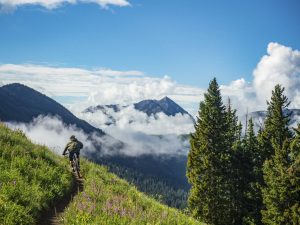
Crested Butte mountain bike trails are some of the most famous and beloved MTB trails in the world. This mountainous region of west-central Colorado, located in Gunnison County, Colorado, contains the popular 401 trail (pictured above) as well as lesser-known gems like Dyke trail. The area’s remoteness and high elevation combine to deliver stunning views and a feeling of seclusion that can be found in few other places on earth. Trails in the zone north and west of Crested Butte tend to be challenging and require some riding on the road. View maps, get trail beta from experts, and plan an awesome mountain biking trip with this Crested Butte MTB guide.
Crested Butte mountain bike trails map
Drag and zoom on the map to explore the best mountain bike trails in Crested Butte, Colorado, including Trail 401. The region described in this guide encompasses the area north of Crested Butte, including Gothic, Washington Gulch, Slate River and Kebler Pass. This zone is known for trails that extend deep into the pristine backcountry of the Gunnison National Forest. For trails closer to the town of Crested Butte, check out the Crested Butte town trails guide.
Crested Butte on Trailforks.com
Crested Butte mountain bike trails
Click or tap on each trail to learn more about it.
Best Mountain Bike Trails in Crested Butte
Trail #401
Trail #401 stats
Distance: 8 miles
Skill level: Intermediate
Trail #401 overview
Trail #401, or “The 401,” appears high on many lists of best mountain bike trails in the world. The trail itself is fun and flowy, but the real payoff of this ride is the scenery. The next couple of paragraphs provide a Trail #401 Crested Butte guide.
Parking for the 401
Park in any of the small roadside lots along Gothic Road in Mt. Crested Butte. The largest parking areas are located at the Judd Falls trailhead and the Rustler Gulch Trailhead. Parking at the top of Schofield Pass is not recommended due to very limited parking availability.
Trail #401 description
Keep reading for the Trail 401 Crested Butte guide. The eight-mile-long 401 trail is usually combined with Gothic Road (also called Schofield Pass Road) to create a 13-mile loop. From the parking lot at Judd Falls or Rustler Gulch, ride north up Gothic Road. Trail #401 begins at the top of Schofield Pass, which is marked with a large, sticker-encrusted sign. Pedal up the punchy singletrack through dark timber for a mile.
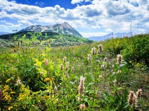
Here, the trees thin out to reveal some of Colorado’s distinctive red peaks, including Mt. Bellview, Avery Peak and Mt. Baldy. Keep climbing for another quarter mile to the trail’s apex at 11,350 feet elevation. Before descending, take in the iconic view of Crested Butte (the mountain) and the rest of Gunnison Valley to the south.
On the descent, the trail cuts across a hillside through a huge field of lush wildflowers in July and August. The hardest part about this downhill is keeping your eyes on the trail instead of the dramatic scenery! The trail switches back several times through the meadow before entering an aspen grove. Just past the five-mile mark, the 401 intersects with Rustler Gulch Road. End the ride here for a shorter loop, or complete the last three miles of singletrack for the full 401 experience.
Due to its high elevation and heavy winter snowfall, the 401 is one of the last Crested Butte mountain bike trails to open each summer. On average, it opens the first week of July, but each year is different. Check CBMBA’s trail conditions page to see if it’s open before attempting to ride it.
A note on the 401
The 401 is one of the most sought-after mountain bike trails in the world due to its remoteness and striking natural beauty. It tops the bucket lists of many riders, making it a popular gathering place. Expect to share the trail with many other mountain bikers (and a few hikers, too). Consider riding the 401 during off-peak times (read: not Saturday morning) to avoid the bulk of other riders.
Riding the 401 is a magical experience and well worth the trek, but the Gunnison Valley is bursting with more than 150 other cool MTB trails to explore, too! Keep reading to learn about lesser-known Crested Butte mountain bike trails that also offer beauty and thrills.
Trail #403
Trail #403 stats
Distance: 4.1 miles
Skill level: Advanced/expert
Trail #403 overview
Next in the Crested Butte MTB guide is Trail 403. This trail cuts between Washington Gulch Road and Schofield Pass Road via the ridge on the north side of Gothic Mountain. The trail’s remote location and seriously chunky downhill portion make it a ride that should only be attempted by seasoned mountain bikers. That being said, the 403 delivers gorgeous views and an adrenaline-charged descent to those committed to riding it.
Trail #403 parking
If riding the loop, park at either end of Snodgrass Trail. If driving a shuttle, park in the limited parking areas at both ends of Trail 403.
Trail #403 description
Riding the 403 requires either setting a shuttle or riding a 20-mile loop via Schofield Pass Road, Snodgrass trail and Washington Gulch Road. The 403 trail itself is only four miles long, so the loop route is recommended because it extends the ride and adds more singletrack via Snodgrass trail. The loop also provides a tour of two of Crested Butte’s most scenic drainages—East River and Washington Gulch.
Steep, technical rock downhill features make the 403 a trail best for skilled riders. Beginning from the west side, climb about a mile and a half to a scenic viewpoint. Grab a drink of water and gaze at the unique pink rock face of Avery Peak to the east.
Crest the ridge and begin riding downhill in the switchbacks through the trees. Eventually, the trees give way to a flower-filled meadow where the trail transitions to steep, rocky step-downs. Hang on! The trail ends at Gothic Campground on Schofield Pass Road.
Deer Creek
Deer Creek trail stats
Distance: 10.7 miles, often ridden as a 28-mile loop
Skill level: Intermediate
Deer Creek trail overview
Another one of the best mountain bike trails in Crested is Deer Creek. This ride is jam-packed with stunning swaths of wildflowers and epic mountain views. Seek this trail out in spring for a pretty ride—it’s usually one of the first trails in the north valley to thaw out.
Deer Creek trail parking
The best place to park for riding Deer Creek is on Brush Creek Road. Parking is limited in the town of Gothic at the north end of the trail.
Deer Creek trail description
Deer Creek is usually ridden south to north. Many riders prefer a hardtail on Deer Creek to maximize efficiency on the hills. Most of the trail follows a mellow grade and can be ridden at a comfortable pedaling pace. The first climb is the steepest and most sustained uphill segment.
The three short descents flow gently downhill and are over before you know it. You’ll be graced with a spectacular view of Gothic Mountain for much of the ride. The trail concludes on Schofield Pass Road in the tiny town of Gothic.
For the 28-mile loop, turn left at Gothic and ride down the hill through Mt. Crested Butte and Crested Butte. Turn left on Brush Creek Road and pedal back to the car. To add more singletrack, ride Upper, Bridges and Upper Upper instead of Highway 135 to get from Crested Butte to Brush Creek Road.
Snodgrass
Snodgrass trail stats
Distance: 4 miles, often ridden as a 14-mile loop
Skill level: Intermediate
Snodgrass trail overview
Easily accessible from Mt. Crested Butte, this trail over Snodgrass Mountain is a Gunnison Valley classic. A stunning display of wildflowers occurs on Snodgrass every summer, making it a destination for mountain bikers and hikers.
Snodgrass seasonal closures
Snodgrass is only open for a few months each summer, so ride it while you can! The trail, which intersects private ranchland, usually closes at the end of August to allow for cattle grazing. Check to see if Snodgrass is open on Crested Butte Mountain Bike Association’s trail conditions page.
Snodgrass parking
There is a large parking lot at the east end of the trail, which is on Gothic Road two miles north of Crested Butte Mountain Resort. Limited parking is also available at the west end of the trail on Washington Gulch Road.
Some riders choose to ride this trail as a 14-mile loop from town. If taking this route, park in downtown Crested Butte and ride up the rec path for five miles to where it ends at the Snodgrass trailhead. Ride Snodgrass Trail, then take Washington Gulch Road back to the rec path and down into town.
Snodgrass trail description
Snodgrass is fun to ride either direction. It is most commonly ridden from east to west due to the easy parking at the east end of the trail. The trail curves through fields of flowers, including glacier lilies, columbine, larkspur, lupine and mule’s ears sunflowers. The initial climb up the east flank of Snodgrass Mountain rewards you with an iconic view of Crested Butte. The trail then climbs into a dreamy aspen grove before descending through another breathtaking wildflower meadow in Washington Gulch.
For more mileage, combine Snodgrass with the Crested Butte town trails, including Lupine, Gunsight Connector and Lower Loop.
Dyke
Dyke trail stats
Distance: 5 miles, often ridden as a 13-mile loop
Skill level: Intermediate/advanced
Dyke trail overview
Experience the beauty of Kebler Pass on a mountain bike. Dyke Trail is a long, challenging ride with some tough uphill portions. For skilled riders, it’s an adventure that’s worth the work. The trail is especially beautiful in fall, when the huge aspen groves on Kebler Pass turn yellow, orange and red.
Dyke trail parking
Park at Horse Ranch Park, 12 miles west of Crested Butte on the Kebler Pass road (County Road 12). This large parking area, which includes equestrian facilities, serves multiple trails. A pit toilet is available.
Dyke trail description
From Horse Ranch Park, ride east on Kebler Pass Road for 3.4 miles. Turn left onto the Kebler Wagon Trail and climb for 1.75 miles. Turn left onto the Lake Irwin Road and ride for two miles. Bear left at the fork to Lake Irwin and left at the next fork too. The Dyke trail begins on the left side of the road.
After a fast and furious downhill section, take another punchy climb up to the Dyke, a spiny rock feature on top of a ridge. Here, the trail intersects with Irwin Trail. At this point, hikers will become prevalent.
Share this amazing trail with other trail users by slowing down and announcing your presence when hikers are around. The last mile and a half of the trail is a delightful downhill romp through aspen groves. The trail ends at Horse Ranch Park.

Baxter-Carbon-Green Lake
Baxter-Carbon-Green Lake stats
Distance: 17 miles
Skill level: Advanced
Baxter-Carbon-Green Lake overview
Riders seeking tough Crested Butte mountain bike trails, look no further! Combine Baxter Gulch, Carbon and Green Lake trails for an epic, thin-air ride through the backcountry west of Crested Butte.
Baxter-Carbon-Green Lake parking
The best way to ride this loop is to park in downtown Crested Butte, since that’s where the Green Lake trail ends.
Baxter-Carbon-Green Lake trail description
Ride south on Highway 135 for about half a mile south of Crested Butte. On the right (west) side of the road is a small parking lot with a map and sign. This is the Baxter Gulch trailhead. Start by climbing Baxter Gulch Trail. This six-mile trail is a sustained uphill route that parallels the pretty creek between Mt. Axtell and Whetstone Mountain.
This climb isn’t technical, and conifer trees provide ample shade. Turn right (north) onto Carbon Trail. This section of the Carbon trail is sometimes referred to as Para Me Y Para Te. The high elevation, combined with large chunks of granite scattered over the trail make this section challenging but scenic. After three miles, Carbon intersects Green Lake Trail.
If you’re up for a side mission, leave your bike here and turn left onto the Green Lake trail. Follow this short spur to Green Lake, a crystal-clear alpine lake tucked into the shadow of Mt. Axtell. Return to your bike and ride the blisteringly steep, rocky eight miles back into Crested Butte on Green Lake Trail. The trail ends behind the Big Mine arena on the southwest side of town. At this point, you’ll probably want to hit up one of the delicious restaurants in Crested Butte!
Frequently Asked Questions about Crested Butte Mountain Bike Trails
Q: When do Crested Butte trails open?
A: The trails in this blog are in the north end of the Gunnison Valley. Due to elevation, they don’t usually melt out until June. Check out the Crested Butte Mountain Bike Association’s trail conditions page to check if the trail you want to ride is open.
Q: What is the best trail in Crested Butte?
A: This depends on who you ask! Crested Butter offers a variety of trails depending on what you’re looking for. Read about other Crested Butte trails on our mountain biking page.
Q: Are there beginner MTB trails in Crested Butte?
A: Yes, Crested Butte offers beginner trails.
Q: Do I need a full-suspension bike?
A: A full-suspension bike is recommended for riding in Crested Butte.
Q: Are there bike rentals in Crested Butte?
A: Yes, most of the bike shops in Crested Butte offer bike rentals.
More trail zones in Crested Butte and Gunnison
The beauty of mountain biking in the Gunnison Valley is the endless selection of trails. Now that you know about the best mountain bike trails in Crested Butte, check out these other trail areas with many diverse route options:
- Brush Creek
- Cement Creek
- Crested Butte town trails
- Gunnison National Forest
- Crested Butte Mountain Bike Park
- Taylor Canyon
- Hartman Rocks
- Signal Peak
Don’t know where to start? Check out our Colorado mountain biking guide for more general MTB info.
What to bring on a Crested Butte mountain biking trip
Many of the trails and routes listed above take many hours and require specialized gear. Check out our guide to packing for a Colorado MTB trip for gear tips
Last updated – May 2026
